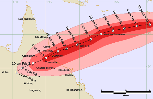
Tropical Cyclone Yasi began developing at a place around the tropical low northwest of Fiji on 29th January and started tracking on a general westward track. The system quickly intensified to a cyclone category to the north of Vanuatu and was named Yasi at 10pm on the 30th by Fiji Meteorological Service. Yasi maintained a westward track and rapidly intensified to a Category 2 by 10am on 31st January and then further to a Category 3 by 4pm on the same day.
Yasi was said to have been a Category 3 intensity for the next 24 hours before being upgraded to a Category 4 at 7pm on 1st February. During this time, Yasi started to take a more west-southwestward movement and began to accelerate towards the tropical Queensland coast.
Yasi showed signs of further intensification and at 4am on 2nd February and was upgraded to a marginal Category 5 system. Yasi maintained this intensity and its west-southwest movement, making landfall on the southern tropical coast near Mission Beach between midnight and 1am early on Thursday 3rd February. Being such a strong and large system, Yasi maintained a strong core with damaging winds and heavy rain, tracking westwards across northern Queensland and finally weakened to a tropical low near Mount Isa around 10pm on 3rd February.
The largest rainfall totals were near and to the south of the cyclone and were generally in the order of 200-300mm in the 24 hours to 9am Thursday. These rainfall totals were experienced in the area between Cairns and Ayr, causing some flooding. The highest totals were; South Mission Beach 471mm, Hawkins Creek 464mm, Zattas 407mm, Bulgun Creek 373mm along the Tully and Herbert River catchments.